

History of Rafting in the Český Krumlov Region
The oldest written mention we can find, regarding the floating of timber in the region of South Bohemia, comes as early as the first third of the 12th century, but the first information about the advantages of navigation on the Vltava river is in the order given by Charles IV, regarding weirs and taxes in 1366.

Only the 16th century brings us other information regarding the floating of timber in an untied manner (which is a typical way for upstream on the Vltava river), as well as rafting, which required a certain flow rate of water, and was therefore used mostly on the middle and lower sections of the Vltava river. In the 16th century navigation became the cheapest way of transport, its importance grew by the requirement for building timber, trading with salt and other articles. Rafting became a part of the lives of people living around the Vltava river (not only Vltava, but even smaller rivers were navigable for example the rivers of Lužnice and Otava), this was also captured in the paintings of Renaissance towns by a well known artist J. Willenberg, when he painted several rafts on a vista of nearby Bechyně.
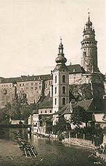
From 1562, Český Krumlov became the first raft binding place on the Vltava river. Further expansion came in 1575, when navigation became totally free without ties to the estates or property. An increase in the importance of rafting during this period is supported both by mention of the existence of the navigational guilds, their patrons and protectors were St. Prokop and St. Mikuláš, and the oldest standards, that have survived, which give the size of one of the "Vltava springs" (width of the spring was around 6 meters).

|

|
Serious alterations to the flow of the Vltava river was brought by the Thirty Years' War (suggestions of Strahov's Abbot, Kryšpín Fuka, 1585 - 1653) and most of all in the 18th century, when the mention of connecting the Vltava river with Dunaj appeared again. During that time several navigational patents and legislation were prepared, adjusting the navigational routine. The reason for the increased effort to make the upstream of the Vltava river navigable and for connecting the rivers of Vltava and Dunaj, was the requirement for the cheap transportation of timber to Vienna and Praha, due to the chronic shortage of timber in large towns. The most famous act of this time - the building of the Schwarzenberg Navigational Canal (which was built between 1787-1789, and completed by a tunnel under Jelení in 1821) - is connected with the name of a Schwarzenberg's architect Josef Rosenauer (1735 - 1804).

Another increase in the trading with timber came in 1823, when the Schwarzenbergs obtained the privilege of exporting timber abroad. The profits from the export of the South Bohemian timber peaked during the second half of the 19th century, when the alterations to the water flow were restricted only to maintenance work, because the railways nearly pushed out the water transport and the level of rafting was sufficient.
|
|
After the first world war, and especially during the economical crisis, the use of rafting was greatly reduced, and the last rafts went through Praha in 1947. After this, rafting was used on the Vltava river on a local scale up to 1960. Neither the characteristic folklore, nor navigational phrases of the once well paid navigators, have survived to the present.
(as)
Further information:
Scenic
cruises
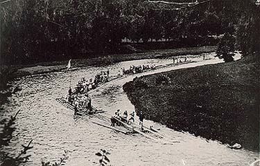
Last
Rafts on the Vltava River
Rafts
on upper Vltava
The
Devil's rock face, attempts to navigate through Devil's
torrents
Construction
Work of Lipno Dam